
Tourism & Cultural Heritage screening
By Global Mining Dataset
We've added Tourism & Cultural Heritage screening to help you understand the places around a mining asset and identify locations that deserve closer attention during early review.
The layer brings together Overture Maps places and UNESCO designations, covering cultural and historic sites, religious and sacred places, natural and visitor attractions, and tourism services. UNESCO coverage includes World Heritage sites, biosphere reserves, global geoparks and cultural property protected under the Hague Convention.
These locations remain separate in the results. A place of worship, a hotel and a heritage designation have different meanings when reviewing an asset.
Why cultural context matters
Mining assets often sit within landscapes that also contain places people use for worship, represent a regions cultural identity, or attract significant amounts of tourism. Knowing what is mapped nearby helps a screening team identify questions about access, heritage and community engagement before more detailed due diligence.
While often not a direct regulatory requirement, recent controversies show that identifying these sites are necessary for mitigating future issues with operating at a given location. At Oak Flat in Arizona, Apache objections to the Resolution Copper project concern a place of religious significance. The U.S. Supreme Court declined to hear Apache Stronghold's challenge in May 2025, and the U.S. Forest Service signed the project's record of decision in March 2026. Cultural and sacred-land questions have remained central to the project debate. The consequences of misses can also last for years. In May 2025, Australia's environment minister called for heritage-protection reform, marking five years since the destruction of Juukan Gorge in 2020 and acknowledging the continuing harm to its Traditional Owners.
The ientificaiton of nearby heritage and sacred places are prompts for further research and engagement. Proximity alone cannot determine cultural significance, consent or an acceptable project outcome.
Explore nearby sites
Open Nearby activity to see tourism and heritage locations on the map alongside other actvity signls including nearby operations, artisanal and small-scale mining, and population context. Hover over an identified location to see its name, distance and supporting information.
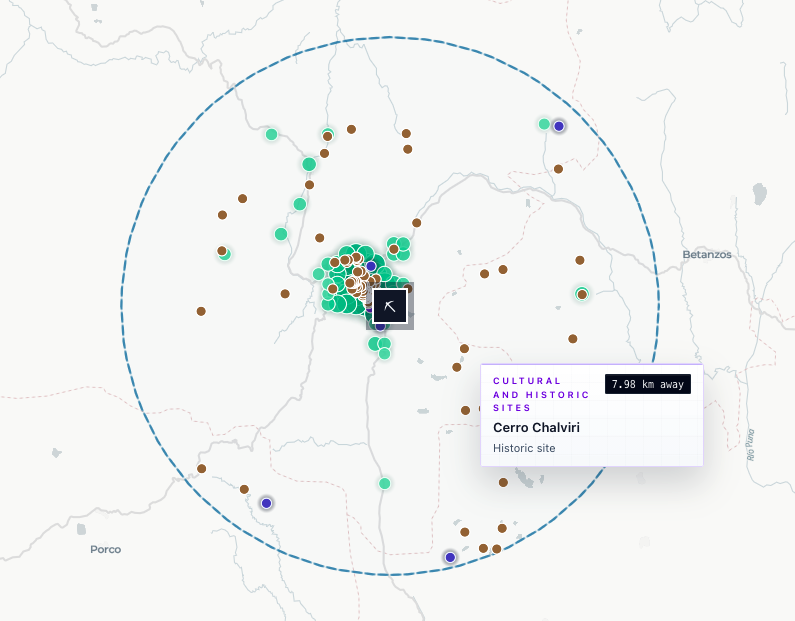
The above image shows an example from Cerro Rico in Potosí in Bolivia. The reference data identifies 43 cultural and historic places and 31 religious and sacred places within 25 km, with the City of Potosí about 1.8 km away. Since these are considered additional context, and not a primary screening signal, these are not combined into an impact score in the same way other metrics are. The presence of tourism and cultural locations does not establish an adverse impact or a legal restriction at the illustrated asset.
Detailed counts and breakdowns can be found when generating a full report, it shows counts within 5, 10 and 25 km, together with the nearest named site where one is mapped within 25 km.
Use the same context across a portfolio
Tourism and heritage criteria are available in Search, saved screenings and CSV exports. You can apply distance and count criteria alongside screening methodolgoies, then review individual assets on the map and in their reports.
Public assets and enterprise-uploaded private assets use the same screening method. Private asset locations are screened against locally held references and are not sent to UNESCO or Overture. The layer is available with premium access; existing private-upload and export permissions continue to apply.
Read the Tourism & Cultural Heritage guide for coverage, interpretation and data credits.